Showing 503 items matching lot 2
-
 Mt Dandenong & District Historical Society Inc.
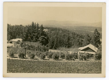
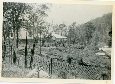
Photograph, Walker's LOT 2
... Walker's LOT 2...View at Kalorama. View over LOT 2 (Walkers) 1922....-and-the-dandenong-ranges Photograph Photograph Walker's LOT 2 Small black ...Harry Walker's property would have been run by his son William in 1922. When the CRB Road cut through the property William planted plum trees on the opposite side. These are visible in this photo. An extensive raspberry crop is in the foreground. The building over the road on the left hand side is the corn and produce store built by Edward John Price (son of Edward Joseph Price) to capitalise on the CRB Road cutting through the Price farm. John Lundy-Clarke grew up in the Kalorama/Mt Dandenong area and later in life (1972-74) began to write a comprehensive history of the area working from an original settlement map in an effort to cover all areas.Small black and white postcard showing a crop in foreground with a house to the right. A road passes through the centre with a house on the left on the opposite side of the road. A view to the ranges in the distance. A handwritten description on reverse by John Lundy-Clarke.View at Kalorama. View over LOT 2 (Walkers) 1922.harry walker, william walker, crb road, raspberry, edward john price, edward joseph price, produce store, store -
 Mt Dandenong & District Historical Society Inc.
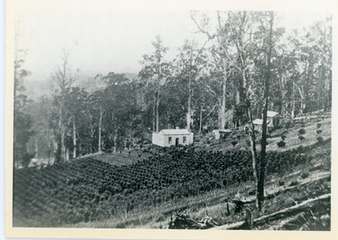
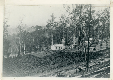
Photograph, Walker's LOT 2
... Walker's LOT 2...Lot 2 was bought by Harry Walker in the early 1900s. Harry...VIEW 1908 OVER LOT 2 SECTION 1 VILLAGE SETTLEMENT. TAKEN...-and-the-dandenong-ranges Photograph Photograph Walker's LOT 2 Black ...Lot 2 was bought by Harry Walker in the early 1900s. Harry was married to Eva Hand, one of the six daughters of Thomas and Eliza Hand. Harry cleared the land and planted half with raspberries that remained productive until c1928. Harry's son William took over the property. The land was cut in half when the new CRB road went through in the early 1920s. John Lundy-Clarke grew up in the Kalorama/Mt Dandenong area and later in life (1972-74) began to write a comprehensive history of the area working from an original settlement map in an effort to cover all areas.Black and white photograph showing a single storey white house in the centre surrounded by crops. Handwritten description on reverse by John Lundy-Clarke.VIEW 1908 OVER LOT 2 SECTION 1 VILLAGE SETTLEMENT. TAKEN FROM RIDGE ROAD THEN MAIN ROAD FROM HALFWAY BETWEEN MOUNTJOY AND FALLS RD. CRB MAIN RD RUNS BEHIND WALKER’S HOUSE. The house seen in the vista among the tall trees beyond the raspberry patch is “Forest Edge” which was George Barber’s home when the picture was taken. The tall trees to the right of the vista were on Price’s LOT 18 and it was while cutting up one of these for firewood that a length of log weighing about ½ a ton got away downhill and leaped in one bounce over Barbers Road and Logan’s house – 1931.harry walker, william walker, eva hand, crb road, raspberries, kalorama -
 Whitehorse Historical Society Inc.
Letter - Correspondence, Offer to buy land in Metropolitan Avenue, Tunstall, 1936
... Lot 2...An offer by T.J. Kiker to buy Lot 2 Metropolitan Avenue... in Metropolitan Avenue, Tunstall An offer by T.J. Kiker to buy Lot 2 ...An offer by T.J. Kiker to buy Lot 2 Metropolitan Avenue, Nunawading and an acknowledgement by Council.An offer by T.J. Kiker to buy Lot 2 Metropolitan Avenue, Nunawading and an acknowledgement by Council.An offer by T.J. Kiker to buy Lot 2 Metropolitan Avenue, Nunawading and an acknowledgement by Council.metropolitan avenue, nunawading, lot 2, shire of blackburn and mitcham, kiker, t.j. -
Ringwood and District Historical Society
Legal record - Conditions of Sale (C.E.Carter), Ringwood - Lot 2, Plan of Subdivision No 12622, C.E.Carter (Agent for William Cross) to Ernest O'Keefe, 1937
... Ringwood - Lot 2, Plan of Subdivision No 12622, C.E.Carter...) Legal record Ringwood - Lot 2, Plan of Subdivision No 12622 ...Particulars and Conditions of Sale of Property , from C.E.Carter (Agent for William Cross) to Ernest O'Keefe. -
Ringwood and District Historical Society
Legal record - Conditions of Sale (C.E.Carter), Ringwood , Lot 1 and part of Lot 2 on Plan of Subdivision (?), Mr H.W.McSweeney and Mrs R.S.Sullivan to Mr J.R.Hitchen, 1946
... Ringwood , Lot 1 and part of Lot 2 on Plan of Subdivision...) Legal record Ringwood , Lot 1 and part of Lot 2 on Plan ...Particulars and Conditions of Sale of Property , from Mr H.W.McSweeney and Mrs R.S.Sullivan to Mr J.R.Hitchen. -
 RMIT Design Archives
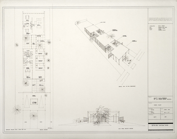
Architectural drawings, Proposed Family Residence for Mr. & Mrs. Spedding at Lot 2 Bolton Avenue, Brighton
... Proposed Family Residence for Mr. & Mrs. Spedding at Lot 2... Family Residence for Mr. & Mrs. Spedding at Lot 2 Bolton Avenue ...Sketh plansink, acetate -
 Eltham District Historical Society Inc
Document, Photocopy of Certificate of Title, Eltham War Memorial Trust, Lot 2, Plan of Subdivision No. 63242, Parish of Nillumbik; derived from Vol. 7073 Fol. 498, 18 May 1964, 1964
... Trust, Lot 2, Plan of Subdivision No. 63242, Parish of Nillumbik... Memorial Trust, Lot 2, Plan of Subdivision No. 63242, Parish ...A4 photocopy Also Shire of Eltham plan of site with proposed security fence highlighted, c.1970 And Plan of Eltham Activity Centre, c.2010certificate of title, eltham war memorial, eltham war memorial trust -
Whitehorse Historical Society Inc.
Document, Notice of default in rate payments, 1933, 1937
... Lot 2... Nunawading Lot 2 Shire of Blackburn and Mitcham Kiker T.J. Freehold ...A notice of default in rate payments to Shire of Blackburn and Mitcham to the Freehold Investment and Banking Co of Australia LtdA notice of default in rate payments to Shire of Blackburn and Mitcham to the Freehold Investment and Banking Co of Australia Ltd and a solicitor's letter requesting more information about the sale of land to T.J. Kiker.A notice of default in rate payments to Shire of Blackburn and Mitcham to the Freehold Investment and Banking Co of Australia Ltdmetropolitan avenue, nunawading, lot 2, shire of blackburn and mitcham, kiker, t.j., freehold investment and banking company of australia ltd, rates -
Whitehorse Historical Society Inc.
Article, Blackburn
... Advertisement for Lots 2&3, The Avenue, Blackburn.... thomas richards burrowes & son Advertisement for Lots 2&3 ...Advertisement for Lots 2&3, The Avenue, Blackburn.Advertisement for Lots 2&3, The Avenue, Blackburn.Advertisement for Lots 2&3, The Avenue, Blackburn.the avenue, blackburn, morton, thomas richards burrowes & son -
Whitehorse Historical Society Inc.
Document, Jones Family History
... 116G, Lot 2, for building of Nunawading South Primary School... and fencing of land, part of Crown Allotment 116G, Lot 2, for building... of Crown Allotment 116G, Lot 2, for building of Nunawading South ...Brief history of the Jones FamilyBrief history of the Jones Family from emigration of James Jones in 1852 to 1970 with papers relating to purchase and fencing of land, part of Crown Allotment 116G, Lot 2, for building of Nunawading South Primary School No 4808, including a native flora area, c 1957. Also papers from the Native Plants Preservation Society of Victoria.Brief history of the Jones Family jones, james, jones family, bette, walter edgar, lionel arthur, kones, k.e. & l.a., native plants preservation society of victoria, nunawading south primary school, no. 4808, mount pleasant road, nunawading, florists, lorikeet street, dagola court, koala avenue -
Whitehorse Historical Society Inc.
Legal record - Land Title, Certificate of Title, 1964 - 1999
... Certificate of Title: Lot 2 Subdivision No 63627, Bruce... Certificate of Title: Lot 2 Subdivision No 63627, Bruce Street ...Certificate of Title: Lot 2 Subdivision No 63627, Bruce Street, MitchamCertificate of Title: Lot 2 Subdivision No 63627, Bruce Street, MitchamCertificate of Title: Lot 2 Subdivision No 63627, Bruce Street, Mitchambruce street, mitcham, land titles, mclennan, doris, peter, dunlavin road -
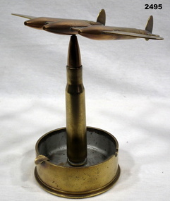 Bendigo Military Museum
Textile - TRENCH ART ASH TRAY, 1940
... “75 mm. M18 LOT 2 - 1306 - 28 BB, CO 1941”.... M18 LOT 2 - 1306 - 28 BB, CO 1941” Military history trench art ...Trench Art made from brass ordnance pieces. The base & stand are made from a 75 mm shell casing & a .50 cal projectile. The top is made from a .50 cal, .303 projectile to form a Lightning Fighter aircarft.“75 mm. M18 LOT 2 - 1306 - 28 BB, CO 1941”military history, trench art, souvenirs, ashtrays -
Whitehorse Historical Society Inc.
Letter - Correspondence, Abattoir Property, 1937
... and Mitcham re sale of Lot 2, Abattoir Estate. A plan of subdivision... sale of Lot 2, Abattoir Estate. A plan of subdivision and list ...Letter between City of Box Hill and Shire of Blackburn and Mitcham re sale of Lot 2, Abattoir Estate. A plan of subdivision and list of allotments for auction by City of box Hill on 27 Oct 1937.Letter between City of Box Hill and Shire of Blackburn and Mitcham re sale of Lot 2, Abattoir Estate. A plan of subdivision and list of allotments for auction by City of box Hill on 27 Oct 1937.Letter between City of Box Hill and Shire of Blackburn and Mitcham re sale of Lot 2, Abattoir Estate. A plan of subdivision and list of allotments for auction by City of box Hill on 27 Oct 1937.land sales, city of box hill, shire of blackburn and mitcham, abattoirs paddock, aspinalls estate, woodhouse grove, box hill north, koonung creek, bishop, herbert thomas -
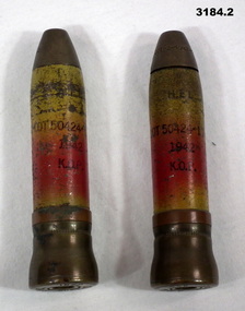 Bendigo Military Museum
Souvenir - TRENCH ART WW2, 1942
... .1) Salt: “ Nose cap: Lot 2-50424-214-42”, Shell: “Lot... cap: Lot 2-50424-214-42”, Shell: “Lot 50424-178 1942 KOP M ....1) & .2) A pair of steel 20 mm cannon shells made into pepper & salt shakers. Brass nose caps have been drilled out, one has 1 hole & the other 3. The sides are painted red & yellow. A brass shell case is crimped down onto the cannon shell. The copper driving band is unused..1) Salt: “ Nose cap: Lot 2-50424-214-42”, Shell: “Lot 50424-178 1942 KOP M” , Base: “20MM-M21 1942 GMS” .2) Pepper: Nose cap: “Lot 2-50424-214-42”, Casing: “Lot 50424-178 1942 KOP”, Base: “20MM-M21 1942 GMS”military history-souvenirs, trench art -
 Kew Historical Society Inc
Plan, Sydney Arnold Best & Co, Field Place, Kew, c.1929
... . Unusually, Lot 2 in Studley Park Road was created from the northern... advertised. Unusually, Lot 2 in Studley Park Road was created from ...Pru Sanderson, in her groundbreaking ‘City of Kew Urban Conservation Study : Volume 2 - Development History’ (1988), summarised the periods of urban development and subdivisions of land in Kew. The periods that she identified included 1845-1880, 1880-1893, 1893-1921, 1921-1933, 1933-1943, and Post-War Development. These periods were selected as they represented periods of rapid growth or decline in urban development. An obvious starting point for Sanderson’s groupings involved population growth and the associated economic cycles. These cycles also highlighted urban expansion onto land that was predominantly rural, although in other cases it represented the decline and breakup of large estates. A number of the plans in the Kew Historical Society’s collection can also be found in other collections, such as those of the State Library of Victoria and the Boroondara Library Service. A number are however unique to the collection.The Kew Historical Society collection includes almost 100 subdivision plans pertaining to suburbs of the City of Melbourne. Most of these are of Kew, Kew East or Studley Park, although a smaller number are plans of Camberwell, Deepdene, Balwyn and Hawthorn. It is believed that the majority of the plans were gifted to the Society by persons connected with the real estate firm - J. R. Mathers and McMillan, 136 Cotham Road, Kew. The Plans in the collection are rarely in pristine form, being working plans on which the agent would write notes and record lots sold and the prices of these. The subdivision plans are historically significant examples of the growth of urban Melbourne from the beginning of the 20th Century up until the 1980s. A number of the plans are double-sided and often include a photograph on the reverse. A number of the latter are by noted photographers such as J.E. Barnes.An unnamed subdivision in Studley Park including five lots for sale in Studley Park Road, Highfield Grove and Tara Avenue. Unidentified on the plan, but clearly existing, are the Henty family mansion of Field Place and Tara Hall in Studley Park Road. The first attempted subdivision of Tara Hall was advertised in 1927 in which Lots 5, 6 and 7 in this plan were also advertised. Unusually, Lot 2 in Studley Park Road was created from the northern part of the Henty mansion, rather than Tara Hall. In the subdivision, lots were advertised at varying prices, with the highest price for land being Lot 2 in Studley Park Road. The plan notes that only one villa is to be allowed on each allotment.subdivision plans - kew, field place subdivision -- studley park – kew (vic.), highfield grove – kew (vic.), tara avenue – kew (vic.) -
Whitehorse Historical Society Inc.
Letter - Correspondence, Municipal rate correspondence, 1933
... Municipal correspondence re rates for shops and Lots 1 & 2... correspondence Municipal correspondence re rates for shops and Lots 1 & 2 ...Municipal correspondence re rates for shops and Lots 1 & 2 Railway Road, Blackburn and correspondence re rates on Lot 23 Central Road, BlackburnMunicipal correspondence re rates for shops and Lots 1 & 2 Railway Road, Blackburn and correspondence re rates on Lot 23 Central Road, BlackburnMunicipal correspondence re rates for shops and Lots 1 & 2 Railway Road, Blackburn and correspondence re rates on Lot 23 Central Road, Blackburnrates, davey, blanche edith, cummins, e (mrs), central road, blackburn, railway road, blackburn -
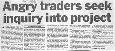 Ringwood and District Historical Society
Newspaper, Scrapbook Clipping, Library Collection, Ringwood, Victoria, `
... $9.9 million Lot 2 development. Civic Place traders claim... $9.9 million Lot 2 development. Civic Place traders claim ...``Newspaper clipping from "The Mail" 18-5-94. Angry traders seek inquiry into project by CHRISTINE McTIGHEAngry Ringwood traders will this week demand a State Government public inquiry into Ringwood Council's handling of it's $9.9 million Lot 2 development. Civic Place traders claim they have suffered massive losses because of the council's actions.` -
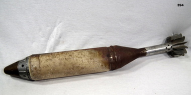 Bendigo Military Museum
Weapon - FLARE, MORTAR, 1960 onwards
... Fuse marked "LOT 10P-2-103-9-68-Can be set up to 25 seconds... marked "LOT 10P-2-103-9-68-Can be set up to 25 seconds" Fin ...Mortar flare, tail fins, casing and timing fuse. Item is in two parts. Tail fin has separated from casing and been partially reinserted at an unusual angle.Fuse marked "LOT 10P-2-103-9-68-Can be set up to 25 seconds" Fin assembly marked "PEO-2-46-68"military-equipment-flares, metalcraft, mortars -
 Kew Historical Society Inc
Plan - Subdivision Plan, Tregarron Estate, Kew, c.1929
... to the extent of lots offered; lots 2 and 3 on the plan were subdivided... to the extent of lots offered; lots 2 and 3 on the plan were subdivided ...Pru Sanderson, in her groundbreaking ‘City of Kew Urban Conservation Study : Volume 2 - Development History’ (1988), summarised the periods of urban development and subdivisions of land in Kew. The periods that she identified included 1845-1880, 1880-1893, 1893-1921, 1921-1933, 1933-1943, and Post-War Development. These periods were selected as they represented periods of rapid growth or decline in urban development. An obvious starting point for Sanderson’s groupings involved population growth and the associated economic cycles. These cycles also highlighted urban expansion onto land that was predominantly rural, although in other cases it represented the decline and breakup of large estates. A number of the plans in the Kew Historical Society’s collection can also be found in other collections, such as those of the State Library of Victoria and the Boroondara Library Service. A number are however unique to the collection.Subdivision plans are historically important documents used as evidence of the growth of suburbs in Australia. They frequently provide information about when the land was sold on which a built structure was subsequently constructed as well as evidence relating to surveyors and real estate and financial agents. The numerous subdivision plans in the Kew Historical Society's collection represent working documents, ranging from the initial sketches made in planning a subdivision to printed plans on which auctioneers or agents listed the prices for which individual lots were sold. In a number of cases, the reverse of a subdivision plan in the collection includes a photograph of a house that was also for sale by the agent. These photographs provide significant heritage information relating house design and decoration, fencing and household gardens.In January 1929, the Kew City Council called for tenders to construct Tregarron Avenue. The subdivision of the Tregarron Estate in Kew was for 11 lots bordering Tregarron Avenue and its entrance from Burke Road. The plan includes annotations that indicate the measurement of each block and the placement of the drainage and sewerage easements. This plan is interesting for a number of factors. The house blocks today have different street numbers, some blocks were to be further subdivided, and at the time of the subdivision, alterations were still being made to the extent of lots offered; lots 2 and 3 on the plan were subdivided and reoriented.subdivision plans - kew, tregarron estate, tregarron avenue -- kew (vic.), burke road -- kew (vic.) -
 Mt Dandenong & District Historical Society Inc.
Photograph, View of Kalorama Gap 1905
... Settlement LOTS 2 and 3 on Ridge (then Main Road) which crosses... of Village Settlement LOTS 2 and 3 on Ridge (then Main Road) which ...Kalorama Gap viewed from the South West in 1908. Ellis Jeeves' 'Mountjoy' is in the centre with the stables to the left. The raspberry patch belongs to Harry Walker and the building centre right to Edward Joseph Price. John Lundy-Clarke grew up in the Kalorama/Mt Dandenong area and later in life (1972-74) began to write a comprehensive history of the area working from an original settlement map in an effort to cover all areas.Black and white photograph showing an extensive raspberry crop in the foreground with a house and outbuilding in the centre and another dwelling centre right. Handwritten description on reverse by John Lundy-Clarke. 1908 view of Kalorama Gap taken from corner of Village Settlement LOTS 2 and 3 on Ridge (then Main Road) which crosses centre of picture with Walker’s driveway dropping left. Walker’s raspberry patch in foreground. “Mountjoy” in centre of picture with coaching stables on left. Price’s house and shop on right showing large cross room used by the Village Settlers for dancing. Mrs Hand’s “Beulah Tearooms” later Mt Dandenong North Post Office is above Price’s roof.kalorama gap, kalorama, harry walker, walker, edward joseph price, raspberry, mountjoy -
 Mt Dandenong & District Historical Society Inc.
Photograph, Harry Walker's Home in Village Settlement 1908, c1908
... 1908 view of H Walker’s home on Village Settle Lot 2... on Village Settle Lot 2 Section 1. Looking from what is now Ridge ...View of Harry Walker's home taken from waht is now known as Ridge Road, Kalorama. Raspberry crops are in the foreground. This photograph has a detailed inscription on the back handwritten by John Lundy-Clarke in 1974.1908 view of H Walker’s home on Village Settle Lot 2 Section 1. Looking from what is now Ridge Road through the trees on Vil. Set Lot 18 to Barber’s house now known as “Forest Edge” on Vil Set Lot 25 down close to the Olinda Creek on Barbers Road. The Estate Agent’s modern office is on the edge of the patch of raspberries at the lower left as the C.R.B. Mt Dandenong Rd passes just behind Walker’s house crossing the picture behind the raspberries.walker, raspberry crop, forest edge, barber -
 Melton City Libraries
Document, Darlingsford land title, 1863
... . Lot 2 – 177 acres 2 rood 23 perches, being Crown portion B... house, milking shed, dairy, U.G. tank. Lot 2 – 177 acres 2 ...Thomas Bell Darling purchased 176 acres from the Toolern Creek to Ferris Road. A house and bluestone barn/stables were built. The property was owned by Ralph Parkinson, followed by Richard Manning. SUMMARY – Darlingsford – Auction 1910 Darlingsford – Auction 1910 Melton Express October FRIDAY, October 28th At Three O’Clock At the RAGLAN HOTEL, MELTON SUBDIVISIONAL SALE of the DARLINGSFORD ESTATE, MELTON. Having a long frontage to the TOOLERN CREEK. In the Estate of the late RICHARD MANNING’ W. S. KEAST and L.A. FAIRBAIRN & CO., Auctioneers (in conjunction). Have received instructions from R.F. and J.L. Robertson, executors of Richard Manning deceased to offer by Public Auction, property almost adjoining Melton township, and having a frontage to the Toolern Creek, subdivided in to four lots as under:- Lot 1. – The homestead block containing 176 acres, being portion A, section 11, parish Kororoit together with the improvements, which consist of a 6-roomed stone house, milking shed, dairy, U.G. tank. Lot 2 – 177 acres 2 rood 23 perches, being Crown portion B of section 11 parish Kororoit. This block adjoins the homestead and is partly fenced. Lot 3 – 187 acres, Crown allotment C, section 11, parish Kororoit. adjoining the above lot. Lot 4 - 157 acres 1 rood 27 perches, being Crown allotment 9, section 12, parish of Kororoit. This block is only divided from the above lots by road, and adjoining Messrs. McVean and Gaitskill’s properties. This is one of the best known properties in the Melton district as a cultivation an grazing form, and its close proximity to the township makes it a very valuable, and portion of which could be cut into township blocks and should command a ready sale. For absolute sale. Terms- one fifth cash, one fifth in eight years, balance in 7 years with interest a the rate of 4 1/2 percent. Plan on application For further particulars apply W.S. KEAST, 610 Collins street, Melbourne; and L.A. FAIRBAIRN & Co., St James-buildings, Williams street, or at Bacchus Marsh; and as to the title, Dugdale and Creber, St. James-buildings, William Street Melbourne. Express November 5, 1910 On Friday last, Mr W.S. Keast and Messrs L.A. Fairbairn & Co., in conjunction, offered at the Raglan the Manning Estate known as Darlingsford, comprising of 700 acres, divided into four lots. Lot 4 was submitted first and passed in at L8 per acre. Lot 1 was then put up and went up to L13 per acre, at which it was also passed in. Lot 3 was next offered, and there being no bid was also passed in. Lot 2 was not offered. Express March 18, 1911 The Manning Estate of Darlingsford 600 acres was sold to Mr. Ernie for an undisclosed price. Note: Map KOROROIT COUNTY OF BOURKE Crown Grant Section 11 Portion A Thomas. B. Darling 176 . 0 . 0 acres on 29.3.1853 Lot 1 Portion B A. Russell 170 . 0 . 0 acres on 29.3.1853 Lot 2 Portion C Peter Inglis 176 . 0 . 0 acres on 29.3.1853 Lot 3 Section 12 Portion 3 P. Inglis 157 . 1 . 27 acres on 17.17.1863 Total 176 170 176 157. 1.27 679 . 1.27 acres November 5th 1910 On Friday night last Mr W S Keast and Messrs L A Fairbairn & Co, in conjunction offered at the Raglan Hotel the Manning Estate known as Darlingsford, comprising of 700 acres, divided into four Lots. Lot 4 was submitted first, and was passed in at L8.0.0. per acre. Lot 1 was then put up and went to L13.0.0. per acre at which it was passed in. Lot 3 was next offered, and then Lot 3 was next offered, and then being no bid was passed in. Lot 2 was not offered. October 22nd Notice of sale. 700 acres of splendid land close to the railway station. Divided onto 4 Lots 3 of which are maiden land and the whole of the acres is chocolate soil. No 1 Lot belonged to the late Mr Ralph Parkinson, and for years was liberally supplied with manure and crushed bones, and is capable of producing many crops.. The property being sold to wind up the Estate. Gisborne Gazette Friday December 17th 1911 Mr Sharp has sold his farm at the back of the township to Mr. E Barrie; price L15/10/ per acre. Agreement between Thomas Bell Darling and Ralph Parkinsonlocal identities -
 Mt Dandenong & District Historical Society Inc.
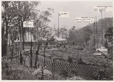
Photograph, 1908 View of the Kalorama Gap from Main Road With Labelling, 1908
... Road above Lot 2 of the Village Settlement. Looking across... Road above Lot 2 of the Village Settlement. Looking across ...Photograph with labels attached to front identifying buildings. View of the Kalorama Gap from main Road (now Ridge Road), looking across Walker's raspberry patch with Mountjoy coaching stables on the LHS and Mountjoy Guest House in centre. Price's house and shop on the RHS. This photograph has a detailed inscription on the back handwritten by John Lundy-Clarke in 1974.1908 View of the Kalorama Gap from main Road – now Ridge Road above Lot 2 of the Village Settlement. Looking across Walker’s raspberry patch with “Mountjoy” coaching stables on left. “Mountjoy” in centre. Prices house and shop on right with Hands “Beulah Tearooms” above Prices roof. On hillside beyond Hand’s is the slope now taken up by Kalorama Terrace. Walker’s well, then newly dug is in lower right hand corner below the tree fern head. Mt Kalorama is the hill top right. Track leaving Main Road left is Walker’s entrance drive.kalorama, kalorama gap, walker, beulah tea rooms, price, hand, mountjoy, mt kalorama -
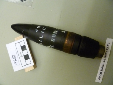 National Vietnam Veterans Museum (NVVM)
Weapon, Bomb Shell
... Firing /REP 259 / MK NI/ AN /1956 MF 40 MM /LOT 281 / 2 / 56 B3... 40 MM /LOT 281 / 2 / 56 B3 REP T &1 Black Bomb - 40mm Bofors ...Black Bomb - 40mm Bofors AA shell (Ran )CP 40 mm ; Balic. MK N2 ; He Sub. T. S.569 Meg 6/69 Plug Firing /REP 259 / MK NI/ AN /1956 MF 40 MM /LOT 281 / 2 / 56 B3 REP T &1bomb shell, bomb, 40mm bofor -
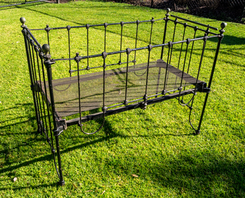 City of Moorabbin Historical Society (Operating the Box Cottage Museum)
Furniture - Iron Cot, Belonging to the Box family, 19thC
... and Elizabeth Box 1835- 1912 who in 1868 purchased 2 Lots of 10acres... purchased 2 Lots of 10acres of the land that was part of the 'Henry ...This Cot was used by the family of William 1834-1902 and Elizabeth Box 1835- 1912 who in 1868 purchased 2 Lots of 10acres of the land that was part of the 'Henry Dendy Special Survey 1841' They established a market garden and raised 12 children while living in Box Cottage. William and Elizabeth Box established a flower garden on 2 lots of the 'Henry Dendy Special Survey 1841' and raised their family living in Box Cottage . A wrought iron cot with spaced vertical bars and with clamps on one side to secure when lowering and raising. The steel mesh base can be removed and wheels are attached to the base of the 4 postswilliam box, box cottage, moorabbin -
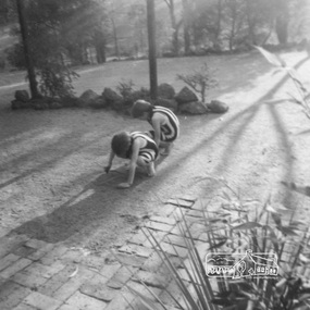
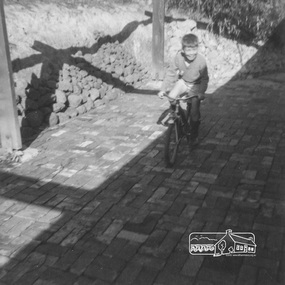
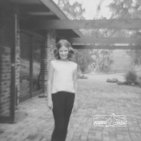
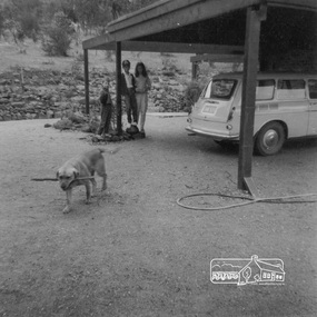
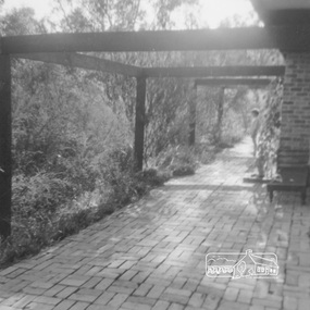 Eltham District Historical Society Inc
Work on paper (item) - Photograph, 2 Metery Road, Eltham South
... at 2 (lot 8) Metery Road, Eltham, a one acre property... designed house at 2 (lot 8) Metery Road, Eltham, a one acre ...Robert and Ada Zull built an Alistair Knox designed house at 2 (lot 8) Metery Road, Eltham, a one acre property for their family of five in the mid 1960s. Susan Bennett, nee Zull's reminiscences are published in EDHS Newsletter, February, April, June, August 2020. This series of photographs together with the account of personal remiscences provide a unique document of the construction of an Alistair Knox designed home. Knox was a pioneer in the use of mudbricks and recycled materials and is significant to his contribution of this style of architecture in Eltham and the wider Shire of Nillumbik.zull family, eltham south, 2 metery road, alistair knox, bush block -
 Eltham District Historical Society Inc
Work on paper (item) - Photograph, 2 Metery Road, Eltham South
... at 2 (lot 8) Metery Road, Eltham, a one acre property... house at 2 (lot 8) Metery Road, Eltham, a one acre property ...Robert and Ada Zull built an Alistair Knox designed house at 2 (lot 8) Metery Road, Eltham, a one acre property for their family of five in the mid 1960s. Susan Bennett, nee Zull's reminiscences are published in EDHS Newsletter, February, April, June, August 2020. This series of photographs together with the account of personal remiscences provide a unique document of the construction of an Alistair Knox designed home. Knox was a pioneer in the use of mudbricks and recycled materials and is significant to his contribution of this style of architecture in Eltham and the wider Shire of Nillumbik.zull family, eltham south, 2 metery road, alistair knox, bush block -
 Eltham District Historical Society Inc
Work on paper (item) - Photograph, 2 Metery Road, Eltham South
... at 2 (lot 8) Metery Road, Eltham, a one acre property... house at 2 (lot 8) Metery Road, Eltham, a one acre property ...Robert and Ada Zull built an Alistair Knox designed house at 2 (lot 8) Metery Road, Eltham, a one acre property for their family of five in the mid 1960s. Susan Bennett, nee Zull's reminiscences are published in EDHS Newsletter, February, April, June, August 2020. This series of photographs together with the account of personal remiscences provide a unique document of the construction of an Alistair Knox designed home. Knox was a pioneer in the use of mudbricks and recycled materials and is significant to his contribution of this style of architecture in Eltham and the wider Shire of Nillumbik.zull family, eltham south, 2 metery road, alistair knox, bush block